




Cyberport & Spatial Data Office of the Development Bureau’s PoC Programme

 Realise Your Entrepreneurial Dreams
In collaboration with Spatial Data Office of the Development Bureau (DEVB), the Proof-of-Concept (PoC) Programme aims to promote the adoption of the Common Spatial Data Infrastructure (CSDI) by encouraging tech ventures to harness technologies such as AI, IoT, geospatial analytics, and BIM in creating innovative digital solutions. The Programme seeks to drive impactful contributions to Hong Kong’s Smart City development.
Selected teams will receive subsidies of up to HK$100,000, mentorship from industry experts, and opportunities to showcase their solutions to potential partners and the public.

PoC Solutions Developed
The programme supported five proof-of-concept projects across GreenTech, ArtTech & Smart Tourism, HealthTech & Wellbeing, Smart Mobility and EdTech. Together, they demonstrate the breadth of possibilities enabled by spatial data and CSDI portal resources.
OneChain Limited
ESGLedger
It connects Reverse Vending Machines (RVMs) to CSDI spatial data to bind every recycling transaction to verified geo-identities, while logging recovery metrics (weight, bottle type, timestamp, coordinates) onto an ISO 27001 permissioned blockchain.
Leveraging a tokenised incentive system, the solution issues instant digital green points and plastic credits to boost community engagement and recycling participation. By using CSDI-anchored audit traits, it eliminates double-counting and cuts ESG compliance turnaround times by 90%.
Media Explorer Limited
TimeWalker.HK
The solution utilises CSDI Map APIs as the base layer to build a digital twin for heritage site exploration, overlaying historical views onto real physical buildings in real time, restoring vanished heritage directly on-site. At the same time, it integrates a multilingual AI chatbot to provide realtime historical context and navigation tips to visitors.
Users can curate digital-physical itineraries to explore internal mini-spots within heritage compounds. Leveraging precise CSDI positioning, users enjoy an instant web-based experience without app downloads. Interactive, mission-based digital stamp tours further enhance visitor engagement, increasing dwell time and footfall across the site.
WayMe Outdoor Limited
WayMe TrailGuard
Combining CSDI terrain, weather, and trail infrastructure data with proprietary geofencing for outdoor navigation, the solution provides smart trail safety assistance. It gives a dynamic TrailComfort Score by calculating a real-time 0–10 comfort and difficulty rating for routes using live weather, elevation, slope, and nearby facilities.
The solution ingests 2,485 POIs across 16 CSDI datasets to map critical facilities like shelters, water points, toilets, and first aid posts, while enabling users to pin geotagged POIs with photos to report fallen trees, landslides, or maintenance needs in real time.
Farmio HK Limited
Farmio SmartPark
The solution decodes static CSDI Road Network traffic rules to display real-time color-coded stopping and loading zone legibility. Real-time IoT sensor data is integrated with CSDI APIs for metered and unmetered roadside parking to show live vacancies. It reduces parking search times by 10–15 minutes per stop.
ConnectAR Limited
Hong Kong City-wide AR Treasure Hunt
The solution was successfully piloted on multi-stop routes at Wong Tai Sin Temple and The Mills. Integrating CSDI 3D maps and Point of Interest (POI) coordinates, it enables 3D street-view navigation and location discovery across Hong Kong. It also uses GPS geo-fencing to guide users along real-world heritage and community trails, with real-time 2D/3D AR content, cultural storytelling, and quizzes as pedestrians reach designated physical waypoints.
The play-to-reward footfall engine connects GPS-verified trail completion to merchant coupon redemptions, encouraging foot traffic and active walkability near local businesses. The platform also allows educators, NGOs, and tourism bodies to build location-based interactive tours.
PoC Programme Innovation Showcase
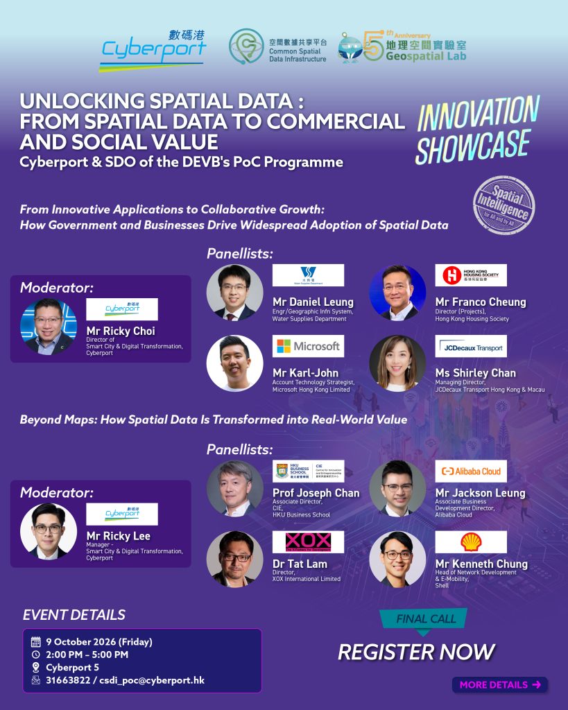
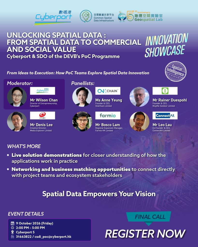
The PoC Programme Innovation Showcase marked the culmination of the year-long programme, bringing together project teams, industry representatives and ecosystem stakeholders at Cyberport to explore the applications and future potential of spatial data innovation.
Through three panel discussions, innovation teams, industry experts and representatives from the government and business sectors explored the journey from concept to execution and from practical application to widespread adoption. They shared how spatial data can address real-world needs, enhance public services and improve business operations.
- Date: 9 October 2026 (Friday)
- Time: 2:00 pm - 5:00 pm
- Venue: Cyberport 5
Programme Highlights
 Up to HKD 100,000 in Funding • Covers development, so you can focus on building, not fundraising |  Networking & Ecosystem Access • Become part of the Cyberport community with access to potential corporate partners and industry collaborators |
 Boost Innovation & Visibility • A great opportunity to bring your PoC to life • Present at pitching sessions, workshops and highlight events — gain media and stakeholders' attention • Get featured on official Cyberport/CSDI channels to amplify your startup’s profile |  Mentorship and Industry Guidance • Benefit from mentorship by experts in the 6 focus areas • Guidance can help refine your solution architecture, business positioning, and pitch |
Eligibility of Application
To be eligible for applying the Programme, applicants must meet all the following criteria:
- Be a company duly incorporated and validly registered in Hong Kong under the Business Registration Ordinance (Cap.310) prior to the date of application.
- Be a company type and engaged in a business scope as specified in Appendix 2 of the Guide and Notes.
- Be the holder of a corporate bank account that corresponds to the applicant company.
Funding Details
Each approved PoC project will receive a maximum subsidy of HK$100,000. The subsidy will be disbursed by HKCMCL to the approved PoC project teams in two instalments.
| Initial Instalment (30%) | Upon approval and signing of the Funding Agreement. |
| Final Instalment (70%) | Upon completion of the PoC project, and after submitting all progress and final reports, attending the themed event, presenting on the final presentation day, and receiving written acceptance from HKCMCL. |
Programme Focus Areas
 Smart Mobility |  FinTech |  GreenTech |
 EdTech |  HealthTech & Wellbeing |  ArtTech & Smart Tourism |
Theme Focused Events
Spatial Data Theme Focused Events
The Spatial Data Theme Focused Events comprise a series of seminars and networking sessions designed to explore the interlinkages among key focus areas: Smart Mobility, GreenTech, EdTech, HealthTech & Wellbeing, and ArtTech & Smart Tourism.
Each event brings together different focus areas to foster cross‑sector dialogue and deeper discussion around a central question: How can spatial data create value and drive innovation across industries?
Event 1: Discover Spatial Data – Data‑Driven Geospatial Learning and Smart Tourism Experiences
- Date: 10 April 2026 (Friday)
- Time: 2:30 pm – 4:30 pm
- Venue: ABC Service Centre, 3/F, Core A, Cyberport 3

Featured Awardee Teams:
- ConnectAR Limited
- Media Explorer Limited
The first event in the series showcased how spatial data can be transformed into practical, real‑world applications across learning and tourism contexts. Featuring live demonstrations from CSDI Proof‑of‑Concept (PoC) awardee teams, the session highlighted innovative solutions that address industry challenges and unlock new business opportunities through spatial data.
Keynote speaker Mr Tse from Tai Kwun also shared its forward‑looking vision on leveraging spatial data to enhance operational efficiency and enrich visitor experiences. With perspectives spanning smart tourism, geospatial learning, and applied spatial technologies, the event provided participants with valuable insights into how CSDI‑enabled solutions can elevate services and open new market possibilities.
Event 2: Geospatial Intelligence for a Smarter City – Smart Parking & Waste Management
- Date: 12 June 2026 (Friday)
- Time: 2:30 pm – 4:30 pm
- Venue: ABC Service Centre, 3/F, Core A, Cyberport 3

Featured Awardee Teams:
- Farmio HK Limited
- OneChain Limited
The second event in the series highlighted how CSDI portal spatial data can support smarter urban mobility and sustainable resource management. CSDI PoC awardee Farmio HK presented a smart alert application for legal stopping zones tailored for professional drivers, while OneChain introduced a spatial data-powered plastic credit tokenization solution to encourage smart recycling.
Keynote speaker Mr Chan from the Environmental Protection Department shared how spatial data-driven planning and digital integration are expanding Hong Kong’s smart recycling network. Keynote speaker Ms Cheung from AS Watson Industries – Watsons Water also shared innovative applications such as reverse vending machines and smart recycling initiatives, supporting sustainable development and moving towards a greener future. The event offered participants perspectives on how CSDI-enabled solutions can enhance city services and support Hong Kong’s smart and sustainable development.
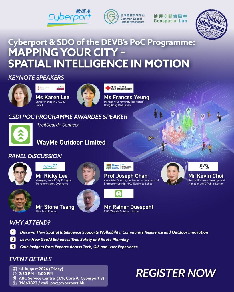
Event 3: Mapping the Wild – Spatial Intelligence in Motion
- Date: 14 August 2026 (Friday)
- Time: 2:30 pm - 5:00 pm
- Venue: ABC Service Centre, 3/F, Core A, Cyberport 3
Featured Awardee Team:
- WayMe Outdoor Limited
The third event in the series focused on urban exploration, community awareness, and public safety, diving deep into how spatial data, GeoAI, and innovative technologies can be applied in real-world scenarios to drive smart city development. CSDI PoC awardee WayMe Outdoor presented its application, combining turn-by-turn navigation, offline maps and real-time location features to bring smarter and more reassuring outdoor exploration experiences.
Keynote speaker Ms Lee from the Hong Kong Polytechnic University Jockey Club Design Institute for Social Innovation shared how spatial data and community insights can foster inclusive services, smart planning and user-centric innovation. Keynote speaker Ms Yeung from Hong Kong Red Cross also showcased how spatial data and real-time hazard information empower the public for disaster preparedness. A panel discussion,“Intelligence in Motion – Elevating Outdoor Experiences with GeoAI”, invited experts, academia, and cloud technology leaders to exchange insights on leveraging GeoAI to address hiking safety and real-time weather challenges. The event highlighted the transformative potential of CSDI applications in shaping more responsive urban solutions and contributing to Hong Kong’s future-ready and sustainable development.
Submit Your Applications
Timeline
| Application Open | 15 Oct 2025 |
| Application Deadline | 30 Nov 2025 (23:59) |
| Shortlisted Applicant Announcement | Mid Dec 2025 |
| Result Announcement | Late Jan 2026 |
*The overall timeframe is shown at the below section for reference.
Required Documents
- Application form (download link)
- PoC proposal (download link) created using the provided template
- Bank statement of one of the major banks for one of the last three months as of application date
- Business Registration Certificate
Submission Method
Applicant must submit the completed application form and the required documents by email to csdi_poc@cyberport.hk before the application deadline.
Important Notes
- Each applicant company shall cover only one PoC project.
- Applicant must complete and submit full set of required documents before submission deadline.
- For a full list of requirements and guidelines, please refer to the Guide and Notes before submission.
- HKCMCL reserves the right to seek additional information from the Applicant at its discretion.
- The application would be considered withdrawn if the additional information/clarification requested by HKCMCL is not provided within the required timeframe ; in the case of such withdrawal, the Applicant may however submit a new application once all the necessary documents and/or requested information are available, provided that the relevant deadlines for application have not passed.
Evaluation Criteria
Each eligible application will be assessed based on individual merits and considered on a case-by-case basis. The assessment criteria and weights are stated as follows:

All application requirements are specified in the Guide and Notes.
Programme Timeline

Remarks: Only shortlisted Applicants will be invited to present their proposals to the External Advisory Panels. If a representative of a shortlisted applicant company is unable to attend the pitching day, the application will be deemed withdrawn from the process.
Reference Materials
| Information Package | Download > |
| Guide and Notes for Applicants | Download > |
| Application Form | Download > |
| Project Proposal Template & Writing Guide | Download > |
Contact Us
Contact HKCMCL for any queries about the Programme and applications. Email: csdi_poc@cyberport.hk